


RunwayMap
Aviation Weather
คำอธิบายของRunwayMap: Aviation Weather
RunwayMap เป็นชุมชนนำร่องอันดับ 1 เกี่ยวกับความรักในการบิน คุณสามารถดูวิดีโอเที่ยวบินรีวิวและภาพถ่ายจากนักบินคนอื่น ๆ รวมถึงแบ่งปันประสบการณ์การบินของคุณ
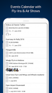
ต้องการแนวคิดสำหรับการเดินทางในวันถัดไปของคุณหรือไม่ ปฏิทินกิจกรรม RunwayMap จะแสดงกิจกรรมเช่นเทศกาลสนามบินการบินและเครื่องบินโบราณ
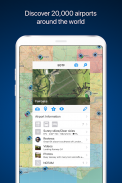
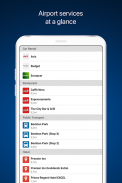
แผนที่เชิงโต้ตอบจะให้ภาพรวมของสนามบิน เราได้รวบรวมข้อมูลสำคัญในทุกสนามบิน:
•การพยากรณ์อากาศการบิน
•รันเวย์ & NOTAM
•มุมมอง 3 มิติและดาวเทียม
•เว็บแคมและอีกมากมาย
RunwayMap ช่วยให้การเตรียมการบินง่ายขึ้นและเติมเต็มเครื่องมือในการวางแผนการบินเช่น SkyDemon, Jeppesen และ Garmin Pilot
ดาวน์โหลดแอพนำร่องที่หลากหลายในขณะที่คุณอยู่
คุณสมบัติ:
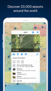
แผนที่
ค้นหาด้วยชื่อหรือ ICAO เพื่อค้นหาสนามบินใหม่ รับข้อมูลสำคัญเช่นสภาพอากาศปัจจุบันที่อยู่ตำแหน่งรันเวย์ NOTAM และพระอาทิตย์ขึ้น / พระอาทิตย์ตก ทำเครื่องหมายและบันทึกสนามบินที่คุณบินไปแล้วหรือที่คุณต้องการบินไปยังสนามบินถัดไป บันทึกบันทึกส่วนตัวของคุณสำหรับทุกสนามบิน
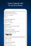
ปฏิทินกิจกรรม
ปฏิทินกิจกรรม RunwayMap จะแสดงกิจกรรมเช่นเทศกาลสนามบินการบินและเครื่องบินโบราณ แต่ละเหตุการณ์จะแสดงระยะทางจากฐานบ้านของคุณไปยังสถานที่จัดกิจกรรมเป็นไมล์ทะเลรวมทั้งนักบินจากชุมชน RunwayMap ก็สนใจที่จะไปด้วยเช่นกัน
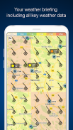
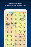
สภาพอากาศการบิน
รายงานสภาพอากาศปัจจุบันสภาพการมองเห็นและการคาดการณ์ลมจะแสดงบนแผนที่ของเรา
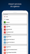
บริการบนเว็บไซต์
ค้นหาร้านอาหารและโรงแรมใกล้สนามบิน รับทราบข้อมูลเกี่ยวกับการขนส่งสาธารณะและบริการรถเช่า
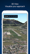
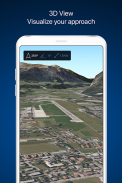
มุมมอง 3 มิติและดาวเทียม
ตรวจสอบสภาพแวดล้อมของสนามบินในมุมมอง 3 มิติและมุมมองดาวเทียม ใช้มุมมอง OpenStreetMap สำหรับข้อมูลการเข้าถึงยานพาหนะอย่างละเอียด
เอกสาร
ด้วยการคลิกเพียงไม่กี่ครั้งเพิ่มเอกสารเที่ยวบินของคุณเช่นแผนภูมิวิธี Jeppesen ขั้นตอนเทอร์มินัล FAA และไดอะแกรมสนามบินคู่มือ SkyDemon หรือคู่มือนักบินของ Garmin วิธีนี้ทำให้คุณอยู่ใกล้มือคุณเสมอ
TOOLS
ใช้เครื่องคิดเลขที่มีประโยชน์สำหรับการแปลงสำหรับระยะทางน้ำหนักอุณหภูมิและอื่น ๆ ให้มันแสดง QNH และ QFE ของคุณ
แอพ RUNWAYMAP
หมายเหตุสำคัญ: RunwayMap ไม่ได้มีไว้เพื่อให้ข้อมูลเกี่ยวกับการบินหรือเครื่องช่วยนำทาง เพื่อจุดประสงค์ในการนำทางเราขอแนะนำให้ใช้เฉพาะข้อมูลการบินที่ได้รับอนุมัติและอัปเดตเช่น SkyDemon, Jeppesen หรือ Garmin Pilot
ข้อมูลสภาพอากาศที่แสดงใน RunwayMap เป็นเพียงข้อมูลทั่วไปเกี่ยวกับการพัฒนาสภาพอากาศที่เป็นไปได้ ไม่ได้แทนที่การบรรยายสภาพอากาศระดับมืออาชีพโดยองค์กรอย่างเป็นทางการก่อนเที่ยวบิน
เรียนรู้เพิ่มเติมเกี่ยวกับ RunwayMap ที่ runwaymap.com
RunwayMap: Aviation Weather--เวอร์ชั่น3.7.0
(08-01-2025)RunwayMap: Aviation Weather - ข้อมูล APK
เวอร์ชั่น APK: 3.7.0แพ็คเกจ: ch.reddev.android.runwaymapเวอร์ชั่นล่าสุดของRunwayMap: Aviation Weather
เวอร์ชั่นอื่น


 3.38
3.38

 4.34
4.34


แอปในประเภทเดียวกัน


